
Background
Overview of Kitchen and Main House
Located at James Madison’s Montpelier, Mount Pleasant is the site of the Madison family’s first plantation in Virginia’s Piedmont region. The excavated site consists of features related to a main dwelling house, a separate kitchen, at least two slave quarters, and a fence line. Portions of three features from this early plantation are included in DAACS: personal adornment items from the cellar of the main dwelling with its associated entrance or drainage trench (Features 100 and 101), and artifacts from a sample of contexts associated with the cellar of the separate kitchen (Feature 42).
Documentary evidence
No documentary evidence relating to the exact location of Mount Pleasant exists. However, oral history placed this as the site of the Madison family’s first plantation in the Piedmont. In addition, its proximity to the Madison family cemetery and the presence of early-18th-century artifacts influenced the decision to excavate here.
Although documentary evidence for the precise location of the site is missing, local courthouse documents, including land plats, wills, probate inventories, and court cases provide a good chronology for the history of Mount Pleasant.
James Madison’s grandfather, Ambrose Madison, and his brother-in-law jointly patented 2600 acres in the Virginia Piedmont. By 1726 it was listed as an established plantation. The people who first lived here were a group of enslaved Africans and Virginians who had been tasked with clearing the land and establishing plantation infrastructure (Chambers 2005). Ambrose Madison, his wife Frances, and their children would not arrive until 1732. Mere months after their arrival, Ambrose died, supposedly by poisoning. Three enslaved individuals: Turk, Dido and Pompey were tried and convicted of conspiring to murder Ambrose Madison (Miller 1995).
After her husband’s death, Frances would manage the plantation until her eldest son, James Madison, Sr. came of age. Then the two shared control until her death around 1760. Around the time of his mother’s death, James Madison, Sr. began construction on a new plantation house, a large Georgian brick dwelling more in line with his rising status than the small frame dwelling at Mount Pleasant. After they moved, Mount Pleasant became incorporated into the main farm complex of the Home Quarter and an overseer’s house built adjacent to the former Mount Pleasant complex. Archaeological research has indicated that by the mid-1760s the main house was razed and by the 1790s all remaining structures associated with the original Mount Pleasant complex were either razed or burnt. A land plat from the sale of the property in 1844 shows that the overseer’s house was still present at that time. It was finally abandoned sometime after that: visitors to the Madison cemetery from the Civil War and afterwards do not mention any activity at the site. In addition, archaeological surveys have not identified any sites in the vicinity that post-date the Madison-land ownership.
Excavation history, procedure, and methods
Mount Pleasant was first identified during surveys in the late 1980s by archaeologists for the National Trust for Historic Preservation, led by Lynne G. Lewis, who uncovered a root cellar associated with one of the earliest structures at the site. Archaeologists returned to the site in 1997 to conduct full-scale excavations searching for the plantation complex where James Madison was born. They uncovered the rest of the plantation service complex, including the cellar for a detached kitchen, a fence line, postholes associated with the early root cellar, and another large pit feature.
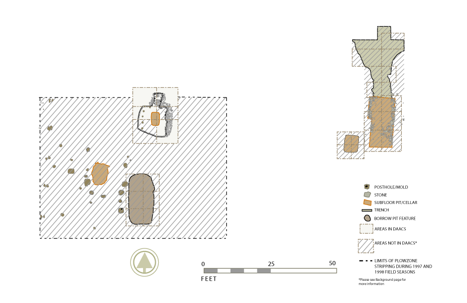
During the 1997-1998 field seasons, archaeologists led by Scott Parker and Tamarra Castillo removed plowzone on a 50-x-70 foot excavation block around the root cellar feature, exposing multiple features. They fully excavated a fence line along with features and postholes associated with the earliest structures (probable slave quarters), as well as the upper layers of the kitchen cellar (Feature 42). The main dwelling was not located during these field seasons. Excavation methodology used a lot and locus system that roughly corresponded to lots as features and loci as natural strata. Plowzone was mechanically striped and sampled, but all soils below plowzone were put through ¼-inch mesh, with waterscreen and flotation samples taken from features.
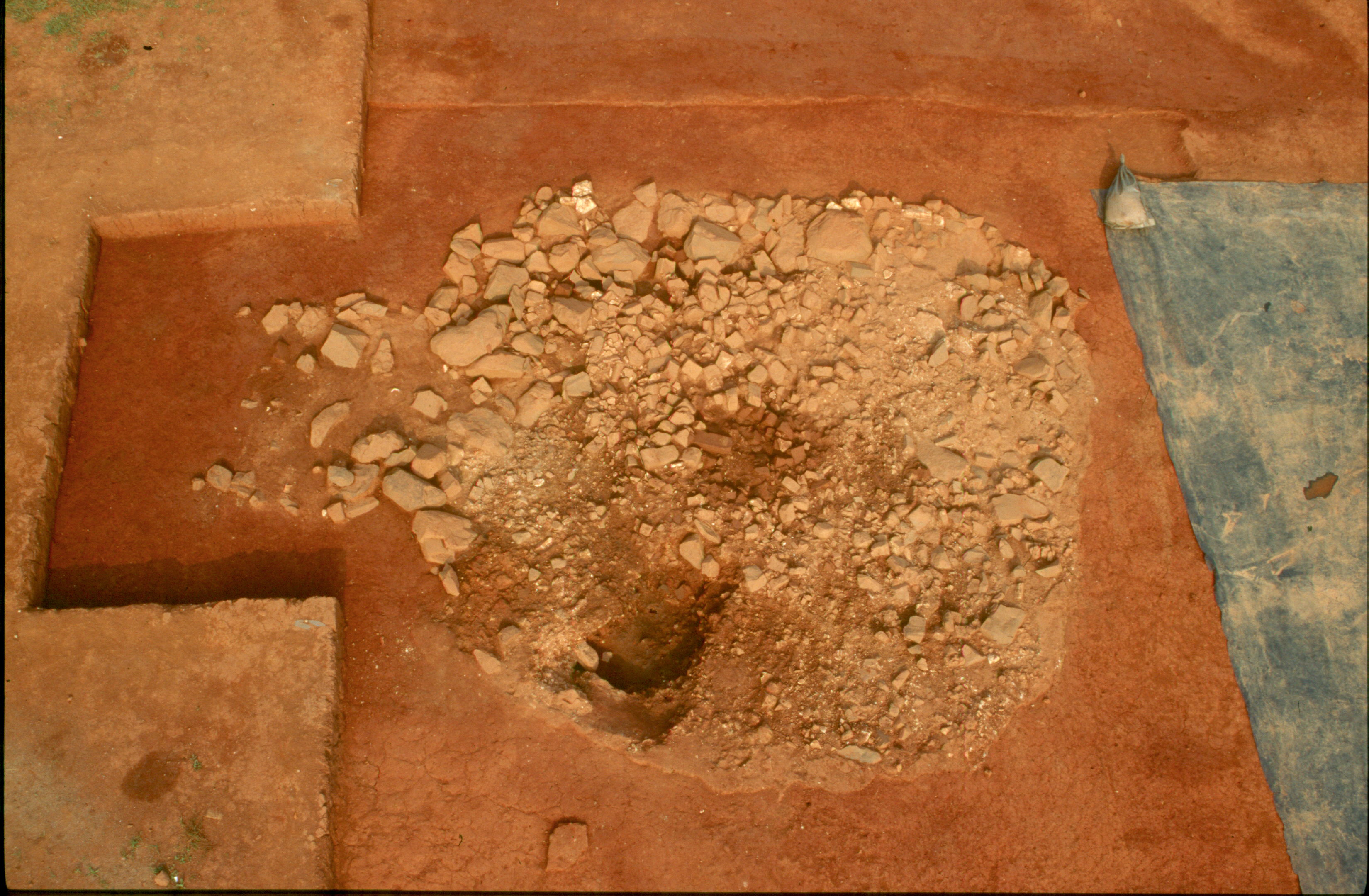
In field seasons from 2000-2001, archaeologists led by Matthew Reeves set out to locate the main dwelling house at Mount Pleasant. A combination of magnetometry, ground penetrating radar, soil
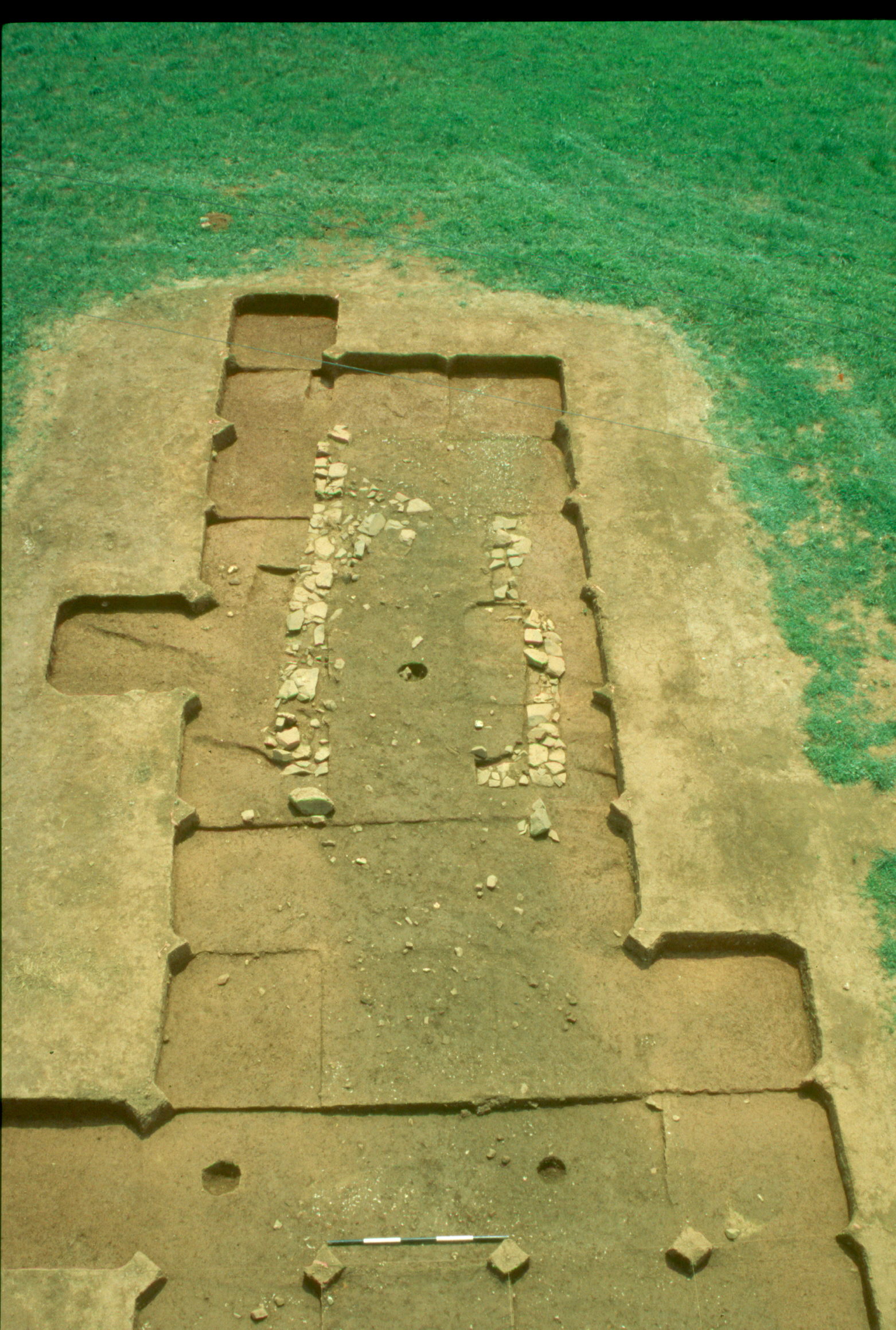
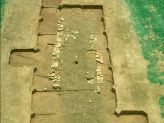
100 exposed prior to excavation.
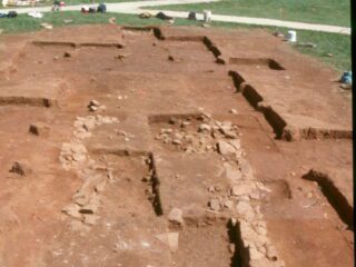
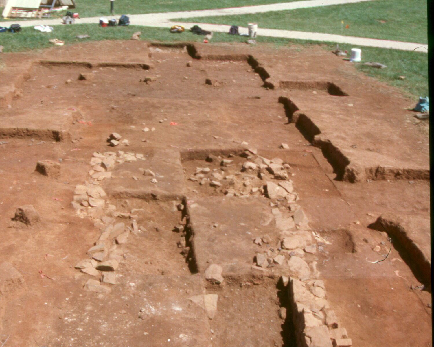
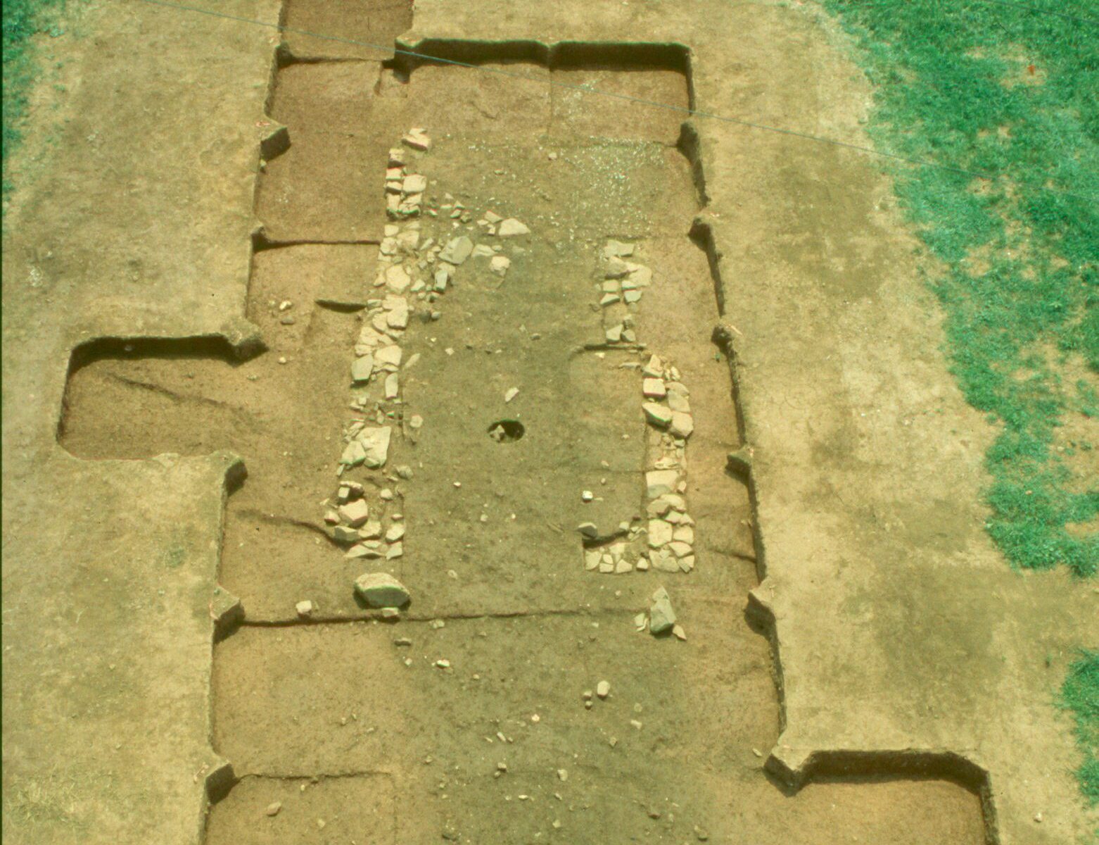
resistivity, shovel testing and metal detector surveys located a promising spot off of the side of the ridgeeast of the kitchen. This area had been missed during the earlier excavations because it seemed like an undesirable location for a plantation dwelling: previous archaeologists had focused their attentions at the top of the landform. Eventually a large area on top of the highest concentrations of artifacts was divided into over 40 5-x-5 foot excavation units to remove plowzone down to subsoil. All plowzone wasscreened through ¼-inch mesh. The removal of plowzone revealed an 18-x-10 foot stone-lined cellar with an entrance trench (Features 100 and 101). Both of these features were sealed by extensive ash-heavy midden deposits. The investigation also revealed another small 6-x-4 root cellar (Feature 108) that seemed to be associated with the main dwelling.
In subsequent field seasons, archaeologists returned to excavate these features. During these investigations the 5-x-5 foot excavation unit grid was altered. Excavation units of varying sizes were placed to bisect the features in such a manner that the best continuous north-south and east-west profiles could be recorded. Within the cellar of the main dwelling (Feature 100), two types of deposits were noted: lower deposits full of plaster, parging and nogging associated with the burning and destruction of the structure (1760s), and overlying midden deposits rich in domestic artifacts (1770s-1780s).
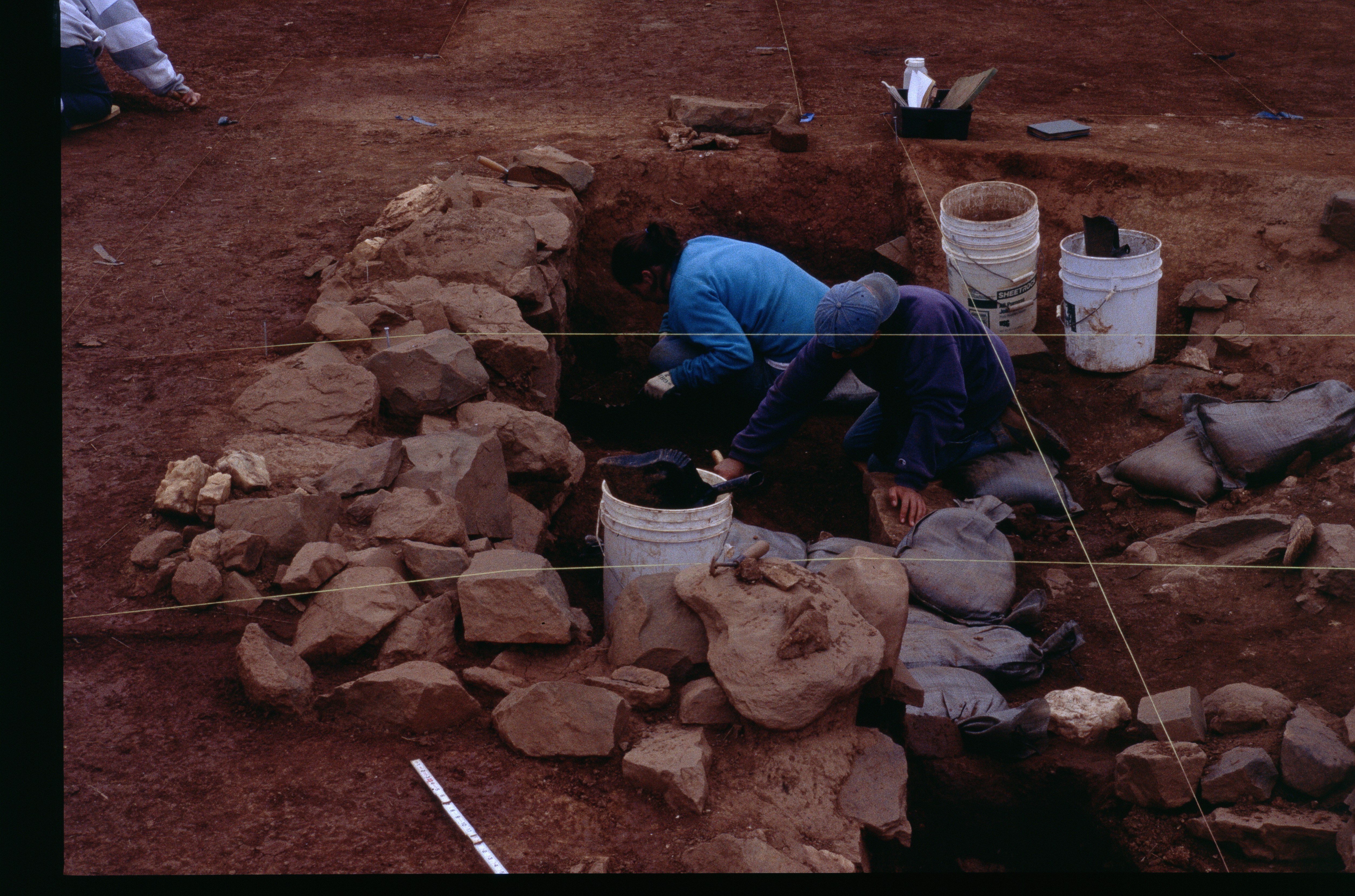
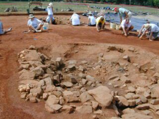
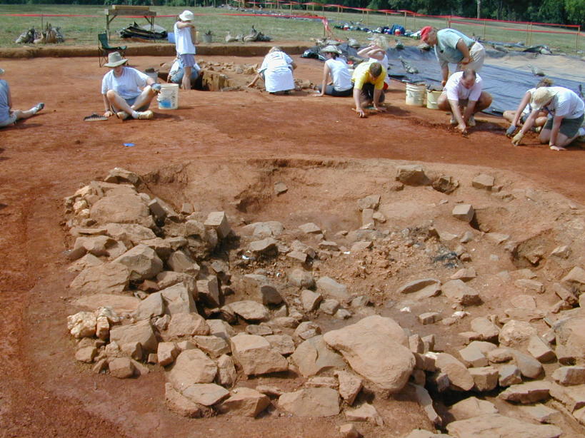
During the 2000s excavations, Montpelier archaeologists also returned to complete the 1990s excavations of the kitchen cellar (F. 42). The lower layers on the kitchen feature were divided into six rectangular units of varying dimensions and excavated at this time. All features were excavated by natural stratigraphy with arbitrary levels used to subdivide strata that were more than .2’ thick. Extensive waterscreen, flotation, microbotanical, and flotation samples were taken. These layers showed that the kitchen had gone through a series of repairs before accidentally burning in the late eighteenth century.
Summary of research and analysis
The stratigraphic history of the features at Mount Pleasant corresponds well with the documentary history of the Madison family’s first plantation in the Piedmont. The earliest structures at the complex are a series of postholes and pit features that contain early-eighteenth-century artifacts. The earliest structure (1720s) is represented by a sub-floor pit. The pit was likely associated with a probable slave quarter, and likely represents the first structure that the enslaved workers built when they arrived at Mount Pleasant in the 1720s. A series of burnt deposits observed in the sub-floor pit suggest that the structure above was destroyed by a fire. A post-in-ground-structure (believed to date to the 1730s) was built atop the burnt remains of the earlier structure. The 1720s structure was pushed into a borrow pit dating to the 1732 construction of the kitchen and main house complex prior to the Madison family arriving from the Piedmont.
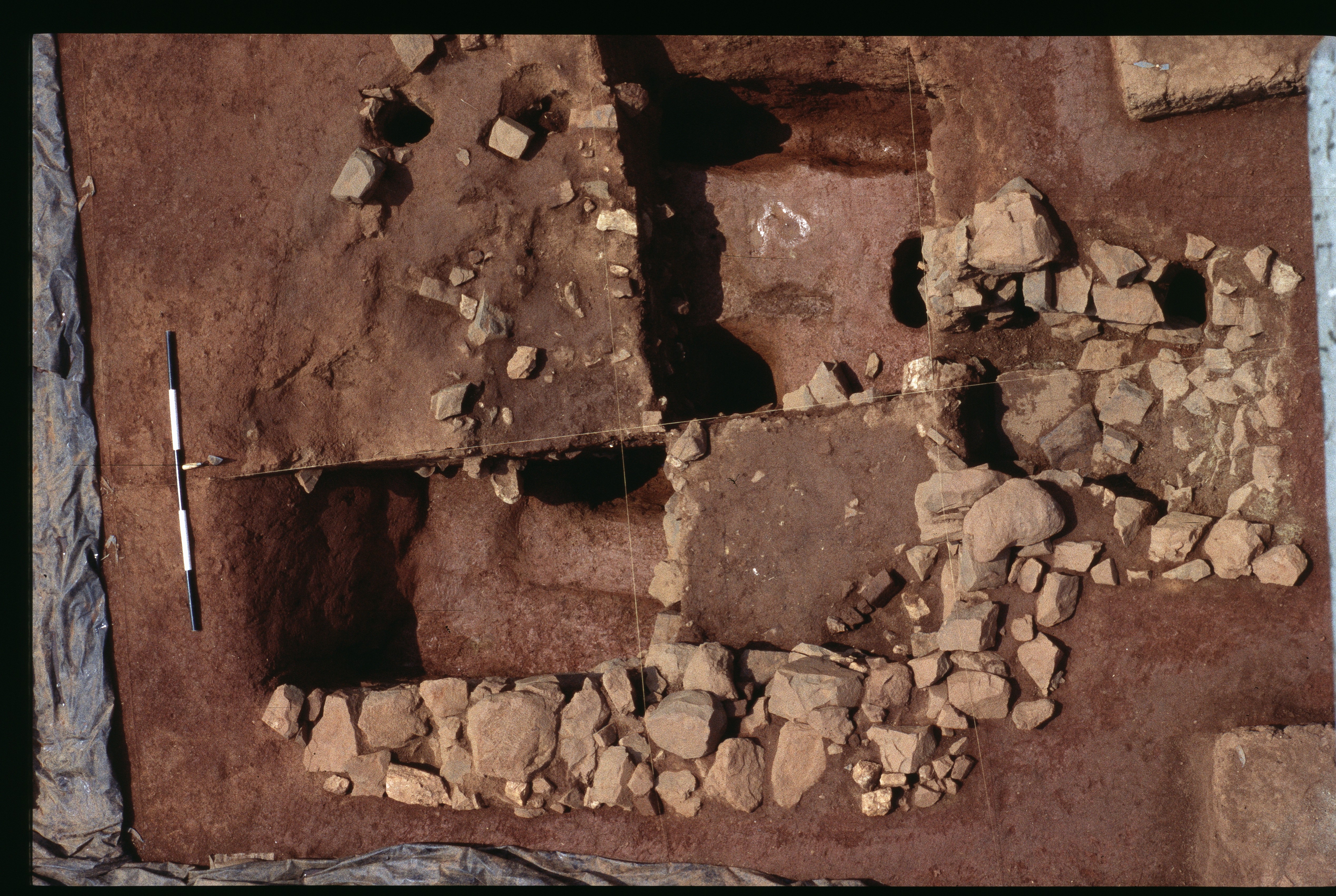
The kitchen consisted of a 12-x-13 foot stone-lined cellar with a 3-foot oval sump at the bottom and a 4-x-5 foot bulkhead entrance. The cellar, sump, and bulkhead entrance were all designated as Feature 42. The bottom layers of this cellar contained early-to-mid-eighteeenth-century artifacts, including a number of wine bottles with the seal of James Madison, Sr. Over this, a series of clay and rubble deposits indicate that the western wall of the cellar had collapsed. The residents of the kitchen repaired the collapse with a post-set wall, evidenced by postholes found on the western side the feature. The cellar was no longer usable after this repair, and it was filled in to help support the new wall. Deposits of hearth ash and ceramics that crossmend with those in the midden on top of the abandoned main dwelling indicate that the kitchen was still being occupied, probably by an enslaved household, after James Madison, Sr. and his family left Mount Pleasant in the 1760s. The deposits associated with this post-1760s occupation of the kitchen are included in DAACS. The kitchen continued to be occupied until around the 1790s, when an accidental fire destroyed the structure. Large numbers of completely mendable creamware and white salt glazed stoneware plates, stacked on top of each other as if for storage, hand painted teawares, personal items, and faunal and botanical remains indicate that the structure was still occupied when it burned.
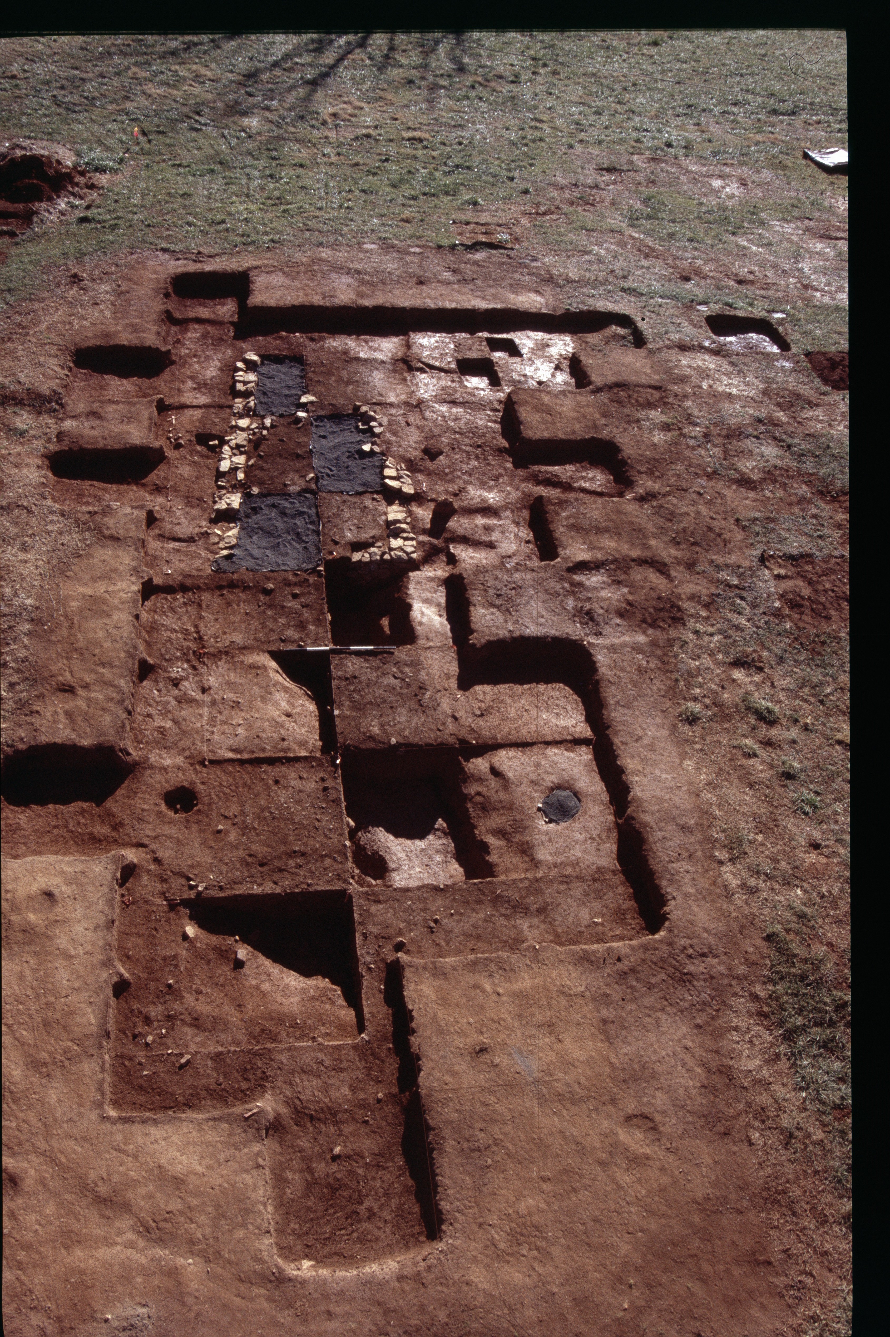
The stone-lined cellar (Feature 100), the root cellar (Feature 108), and the entrance trench (Feature 100) are the primary features that make up the main dwelling. The combination of the root cellar and architectural artifacts that continue beyond the stone-lined cellar indicate the footprint of the house included the root cellar. Evidence for intentional burning comes from the relative absence of architectural hardware and domestic items. In addition, stratified and well-sorted layers of wall plaster and noggin suggest a careful destruction and then burning of the main house. It seems that after the Madison family moved to their new residence, the structure was burned to remove it from the landscape and salvage any useful architectural items. A collapsed wooden crib wall in the west side of the cellar and extensive damage to the foundations indicate that the structure was in too much disrepair to be worth salvaging by the 1760s.
After the destruction of the main dwelling, its cellar was used as a midden by the enslaved household still living at the Mount Pleasant complex. Ceramic crossmends between these midden deposits and deposits in the kitchen indicate that the people living in the kitchen were using the main dwelling cellar as a dump for their domestic refuse.
Reeves and Fogle
Reeves and Fogle analyzed field records and artifacts from over a decade of excavations carried out at Mount Pleasant (Reeves and Fogle 2007a). The analysis focused on integrating data created from different excavation methods and working out the depositional history of the site. The investigation also examined the relationship between deposits in the cellar of the service complex and that of the main house. A critical part of the analysis consisted of grouping individual strata into what were called Site Strata (SS#). During excavations, individual layers of sediment where the excavators identified differences in sediment color and texture were assigned separate context numbers. During the 2006-2007 analysis contexts with similar sediment texture, inclusions, and artifacts were aggregated into site strata. These site strata were used to group the individual contexts excavated in separate units that were associated with each other. The purpose of aggregating these unit strata was to identify individual depositional episodes of the site. For a more detailed explanation of this process please see Reeves and Fogle 2007a:5.
The analysis identified 77 site strata for Mount Pleasant based on the data from previous excavations (for detailed explanations of each site stratum see Reeves and Fogle 2007b). The analysis also identified deposits that are believed to be from the same period based on similarities in deposit sediments and ceramic cross mends. Painstaking cross mending of all ceramics from across features of the site provided strong evidence for associated deposits between the main house and the kitchen cellar fill deposits.
Smith
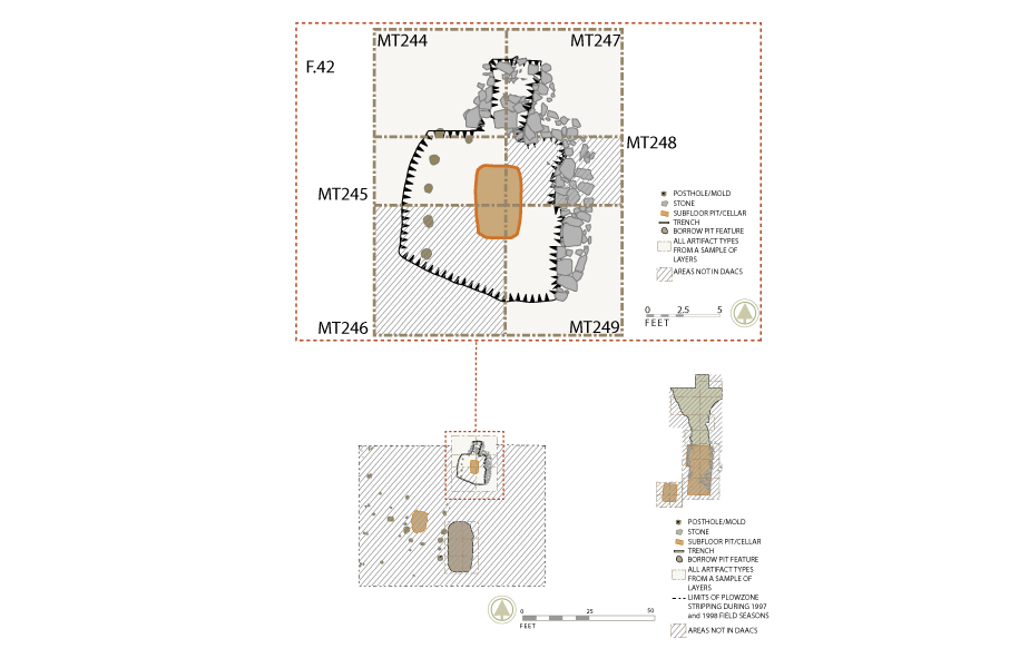
As a DAACS Research Consortium partner and as part of her dissertation research Smith is conducting a fine-grained study of contexts and artifacts from a sample of features at Mount Pleasant. Her research question has shaped the data currently available in DAACS. Smith’s research examines how the power structures of institutionalized slavery shaped the materially-expressed identities of both enslaved and free members of Mount Pleasant. Consequently, her analysis has focused on items of personal adornment, which include beads, buttons, buckles, straight pins and utensils. She chose to focus on a sample of site
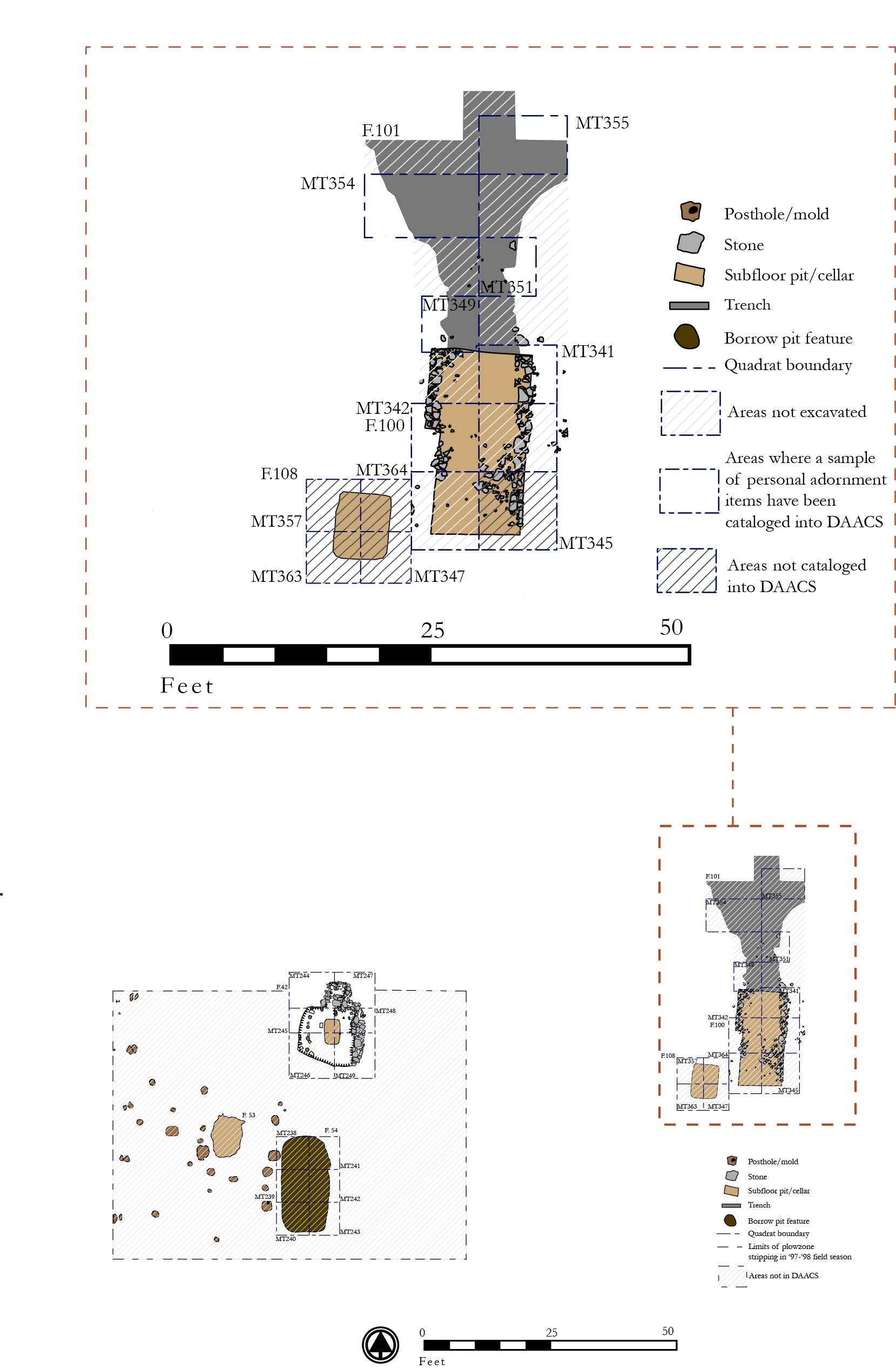
strata associated with Features 42, 100, and 101, the kitchen cellar and the main house cellar and entrance trench. Within these features Smith has focused on a sample of contexts that Reeves and Fogle’s analysis identified as post-repair occupation-related strata (those related to the period prior to the kitchen burning but after the cellar collapse)—Site Strata 102 and 108—and one strata that was identified as transitional, SS 110. All of the artifacts associated with the sample of occupation-related contexts for Feature 42 have been entered into DAACS (see table below). In addition, a sample of personal adornment items has been entered for contexts associated with Features 100 and 101 that Reeves and Fogle identified as Site Strata 11. SS 11 is believed to be contemporaneous to SS 102 and 108 in Feature 42 based on ceramic cross mends.
It should be noted the site strata that were used as the basis for choosing the sample were not developed using the same methods as DAACS stratigraphic groups. Smith’s analysis of Feature 42 context records did not allow her to define stratigraphic groups for the contexts associated with that feature. Thus, as with other sites in the Archive, the DAACS seriation chronology for Mount Pleasant was derived from ceramic assemblages aggregated at the level of individual contexts not assigned to stratigraphic groups.
| Feature 42¹ | Total # of Artifacts Cataloged into DAACS | Total # Artifacts not Cataloged in DAACS (percentage of artifact class that is not cataloged) | Total Artifacts in Feature Assemblage² |
|---|---|---|---|
| Beads | 3 | 0 (0%) | 3 |
| Buckles | 3 | 0 (0%) | 3 |
| Buttons | 10 | 1 (10%) | 11 |
| Ceramics | 246 | 0 (0%) | 0 |
| Faunal | 11 | 1067 (98%) | 1078 |
| All Other Artifacts | 6778 | 0 (0%) | 6778 |
| Glass | 250 | 0 (0%) | 250 |
| Tobacco Pipes | 62 | 0 (0%) | 62 |
| Utensils | 1 | 0 (0%) | 1 |
| Total Artifacts | 7,364 | 1068 (12.6%) | 8432 |
| ¹ A sample of contexts from Feature 42 have been entered into DAACS. See the Before You Begin Page for a list of the contexts that are in DAACS. | |||
| ² Total artifacts from the contexts entered into DAACS. | |||
| Feature 100¹ | Total # of Artifacts Cataloged into DAACS | Total # Artifacts not Cataloged in DAACS (percentage of artifact class that is not cataloged) | Total Artifacts in Feature Assemblage² |
|---|---|---|---|
| Beads | 1 | 0 (0%) | 1 |
| Buckles | 0 | 0 (0%) | 0 |
| Buttons | 3 | 1 (25%) | 4 |
| Ceramics | 0 | 76 (100%) | 76 |
| Faunal | 0 | 471 (100%) | 471 |
| All Other Artifacts | 58 | 6552 (99%) | 6610 |
| Glass | 0 | 62 (100%) | 62 |
| Tobacco Pipes | 15 | 26 (63%) | 41 |
| Utensils | 1 | 1(50%) | 1 |
| Total Artifacts | 78 | 7189 (99%) | 7267 |
| ¹ A sample of contexts from Feature 100 have been entered into DAACS. See the Before You Begin Page for a list of the contexts that are in DAACS. | |||
| ² Total artifacts from the contexts entered into DAACS. | |||
| Feature 101¹ | Total # of Artifacts Cataloged into DAACS | Total # Artifacts not Cataloged in DAACS (percentage of artifact class that is not cataloged) | Total Artifacts in Feature Assemblage² |
|---|---|---|---|
| Beads | 1 | 0 (0%) | 1 |
| Buckles | 0 | 5 (100%) | 5 |
| Buttons | 0 | 9 (100%) | 9 |
| Ceramics | 1 | 391 (99%) | 392 |
| Faunal | 0 | 2872 (100%) | 2872 |
| All Other Artifacts | 172 | 10359 (98%) | 10531 |
| Glass | 0 | 326 (100%) | 326 |
| Tobacco Pipes | 0 | 61 (100%) | 61 |
| Utensils | 6 | 11(64.7%) | 17 |
| Total Artifacts | 189 | 14025 (98.6%) | 14214 |
| ¹ A sample of contexts from Feature 101 have been entered into DAACS. See the Before You Begin Page for a list of the contexts that are in DAACS. | |||
| ² Total artifacts from the contexts entered into DAACS. | |||
DAACS
Based on the correspondence analysis DAACS divided the Mt. Pleasant Kitchen Site occupation into three phases. Mean ceramic dates for the site-specific phases are given in the table on the chronology page. Although the correspondence-analysis did identify Phases the Dimension 1 by BLUE MCD plot compared with the site’s Harris Matrix clearly indicates that the Feature 42 contexts were a jumble of secondary refuse dating from the second and third quarters of the eighteenth century. Note that a stratigraphically higher context (L42lot9) has the earliest date while context it seals (stratigraphically lower context L42lot19) has a later date.
Matt Reeves and Hope Smith
Montpelier Foundation and University of Tennessee
March 2015
Before You Begin
Things you need to know about the site before you use the data:
-
- Only a sample of the artifacts recovered from the Mount Pleasant excavations are included in DAACS. These include complete contexts for the kitchen occupation layers that post-date the repairs made to the kitchen (F. 42) and pre-date the destruction of the structure. Artifacts from the main house cellar only include artifacts of personal adornment (buttons, beads, straight pins, and other objects used to construct appearance) recovered from midden deposits lying on top of the rubble from the destroyed main house (F. 100) and entrance trench (F. 101). These contexts contain an unusual variety of such objects. They were included to give a full sense of the items of personal adornment that were associated with this period of occupation at Mount Pleasant.
- Faunal analysis has already been conducted on these features, and faunal material (other than shell) is not included in DAACS. For the faunal information, please refer to Pavao-Zuckerman (2002).
- During the 1998-1999 field seasons, features were excavated using a locus and lot system. For the excavations at the Mount Pleasant kitchen, the lot number corresponds to the feature number (e.g. locus 42 is feature 42), and lot numbers correspond to natural strata (e.g. Lot 17, shortened to lot17 in the DRC application).
- During the 2000-2001 field seasons, the system was changed to rectangular excavation units on a grid pattern and natural strata designated with letters (e.g. MT245.E).
- The upper layers of the kitchen (Feature 42) were excavated using the lot and locus system. The lower layers were excavated using excavation units. While natural stratigraphy was followed during both excavations, not enough information was available to enable the merging of the locus/lot contexts identified from the 1998-1999 excavations with those uncovered in 2000-2001. As a result two separate Harris Matrices were generated to represent the relationships between stratigraphic groups for each excavation season.
- The main dwelling house was uncovered during the 2000-2001 field seasons and was excavated using MT units and lettered strata.
- Measurements are in feet and tenths of feet.
- Montpelier uses a system of site strata to group together layers associated with distinct cultural depositional events. These site strata and interpretations are recorded in DAACS under the Master Context fields.
- Inventory codes, ceramic vessel numbers, and ceramic mend numbers from the Montpelier catalog system and vessel analyses are recorded in the Notes field for each artifact.
- The following table lists the contexts for Feature 42, 100, and 101 that have been cataloged in DAACS.
| Contexts Cataloged in DAACS | |
|---|---|
| Locus/Feature 42 | Lot 9, Lots 15 through 17, Lots 19 and 20 MT.244/247.F42.H, MT.244/247.F42.J, MT244.F42.B, MT244.F42.C, MT244.F42.D, MT244.F42.E, MT245.F42.E, MT245.F42.G, MT247.F42.D, MT247.F42.E, MT247.F42.F, MT249.F42.F, MT249.F42.G, MT249.F42.G2, MT249.F42.H |
| Feature 100 | MT341.F100.A, MT341.F100.B, MT341.F100.D, MT341.F100.D2, MT342.F100.A, MT342.F100.B |
| Feature 101 | MT342.F101.B, MT349.F101.A, MT349.F101.B, MT351.F101.A, MT351.F101.B, MT354.F101.B, MT354.F101.B2, MT.354.F101.H, MT.355.F101.B2, MT.355.F101.B3, MT.355.F101.B4, MT.355.F101.C, MT.355.F101.J1, MT.355.F101.J5 |
- The following tables show which contexts for Features 42, 100, and 101 have not been cataloged in DAACS. The artifacts associated with these contexts are cataloged by James Madison’s Montpelier Archaeology Department. Please note that there are no O contexts (e.g. MT249.F42.O).
Contexts not included in DAACS:
| Kitchen Cellar F.42 | |||
|---|---|---|---|
| Locus 42 | Lots 1 through 8, Lots 10 through 14, Lots 21 through 35 |
||
| MT244.F42 | MT244.F42.A, MT244.F42.F, MT244.F42.G | ||
| MT247.F42 | MT247.F42.A, MT247.F42.B, MT247.F42.C | ||
| MT244/247.F42 (lower layers of bulkhead entrance) |
MT244/247.F42.K, MT244/247.F42.L | ||
| MT245.F42¹ | MT245.F42.A, MT245.F42.B, MT245.F42.D, MT245.F42.F, MT245.F42.H, MT245.F42.J, MT245.F42.K, MT245.F42.L, MT245.F42.M, MT245.F42.N, MT245.F42.P, MT245.F42.Q |
||
| MT249.F42² | MT249.F42.A, MT249.F42.B, MT249.F42.J, MT249.F42.K, MT249.F42.L, MT249.F42.M, MT249.F42.N, MT249.F42.P, MT249.F42.Q, MT249.F42.R, MT249.F42.S, MT249.F42.T, MT249.F42.U, MT249.F42.V,MT249.F42.W, MT249.F42.X, MT249.F42.Y |
||
| ¹ ² MT245 and MT249 have so many strata because these units encompassed the deepest part of the kitchen cellar, which formed a sump in the center of the feature. Strata that are missing are strata that were designated but not excavated, generally because theywere determined to be part of the original cut of the feature into subsoil. | |||
| Main House Cellar F.100 | |
|---|---|
| MT341.F100 | MT341.F100.C, MT341.F100.F, MT341.F100.G, MT341.F100.H, MT341.F100.J |
| MT342.F100 | MT342.F100.C, MT342.F100.D, MT342.F100.E, MT342.F100.F, MT342.F100.G, MT342.F100.H, MT342.F100.J, MT342.F100.K, MT342.F100.L, MT342.F100.M, MT342.F100.N |
| MT345.F100 | Entire Unit: The ashy midden deposits (SS11 or SG1) were so shallow that they were mixed into the cellar destruction deposits and could not be excavated as a separate layer. |
| Main House Cellar Entrance Trench F.101 | |||
|---|---|---|---|
| MT341.F101¹ | MT341.F101.A, MT341.F101.B, MT341.F101.C | ||
| MT349.F101 | MT349.F101.C, MT349.F101.D, MT349.F101.E, MT349.F101.F, MT349.F101.G, MT349.F101.H, MT349.F101.J, MT349.F101.K |
||
| MT351.F101 | MT351.F101.C, MT351.F101.D | ||
| MT354.F101 | MT354.F101.A, MT354.F101.C, MT354.F101.D, MT354.F101.E, MT354.F101.F, MT354.F101.G, MT354.F101.H, MT354.F101.J, MT354.F101.K |
||
| MT355.F101 | MT355.F101.A, MT355.F101.C, MT355.F101.D, MT355.F101.E, MT355.F101.F, MT355.F101.G, MT355.F101.H, MT355.F101.J, MT355.F101.K, MT355.F101.L, MT355.F101.M, MT355.F101.N, MT355.F101.P, MT355.F101.Q |
||
| ¹ MT341 contained both cellar (F.100) and entrance trench (F.101) deposits. Ashy midden deposits (Site Stratum 11 or SG 1) overlay both the entrance trench and cellar in a continuous deposit. In this unit, the ashy midden deposits are included with Feature 100, not Feature 101 | |||
Site Features
Feature Numbers
The original excavators of the Mount Pleasant site assigned numbers to individual features. Between 1997 and 2003, all archaeological features identified at Mt. Pleasant were assigned consecutive feature numbers. Context information from three features, Feature 42, Feature 100, and Feature 101 has been entered into DAACS.
Feature Groups
Feature groups are sets of features whose spatial arrangements indicate they were part of a single structure (e.g. structural postholes, subfloor pits, and hearth) or landscape element (e.g. postholes that comprise a fenceline). Feature Groups at Mt. Pleasant were assigned by DAACS and they have a FG-prefix, which precedes the number (i.e. FG01 equals Feature Group 1). FG01 encompasses the Cellar (F.100) and Entrance Trench (F.101) and from the Mount Pleasant Main House.
| Feature | Feature Type | Contexts |
|---|---|---|
| F100 | Cellar | MT341.F100.A, MT341.F100.B, MT341.F100.D, MT341.F100.D2, MT342.F100.A, MT342.F100.B |
| F101 | Trench, unidentified (Entrance Trench) | MT342.F101.B, MT349.F101.A, MT349.F101.B, MT351.F101.A, MT351.F101.B, MT354.F101.B, MT354.F101.B2, MT.354.F101.H, MT.355.F101.B2, MT.355.F101.B3, MT.355.F101.B4, MT.355.F101.C, MT.355.F101.J1, MT.355.F101.J5 |
| Feature | Feature Type | Contexts |
|---|---|---|
| F42 | Cellar | Lot 9, Lots 15 through 17, Lots 19 and 20 MT.244/247.F42.H, MT.244/247.F42.J, MT244.F42.B, MT244.F42.C, MT244.F42.D, MT244.F42.E, MT245.F42.E, MT245.F42.G, MT247.F42.D, MT247.F42.E, MT247.F42.F, MT249.F42.F, MT249.F42.G, MT249.F42.G2, MT249.F42.H |
Chronology
Intra-site Chronologies
DAACS has developed a uniform set of methods to infer intra-site chronologies for all of the sites included in the archive. These methods, which include frequency-seriation and correspondence analysis, were developed by DAACS (see Neiman, Galle, and Wheeler 2003 for technical details). The use of common methods for all sites in the archive is designed to increase comparability among temporal phases at different sites. The methods and the phase assignments they produced are summarized below. Archive users may also use the Mean Ceramic Date queries provided on the Query the Database section of this website to calculate MCDs for individual contexts or features.
DAACS Seriation Method
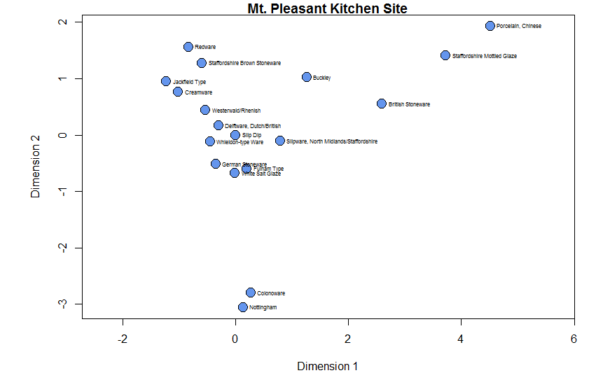
As with other sites in the Archive, the seriation chronology for Mt. Pleasant was derived from ceramic assemblages of individual contexts not assigned to stratigraphic groups.
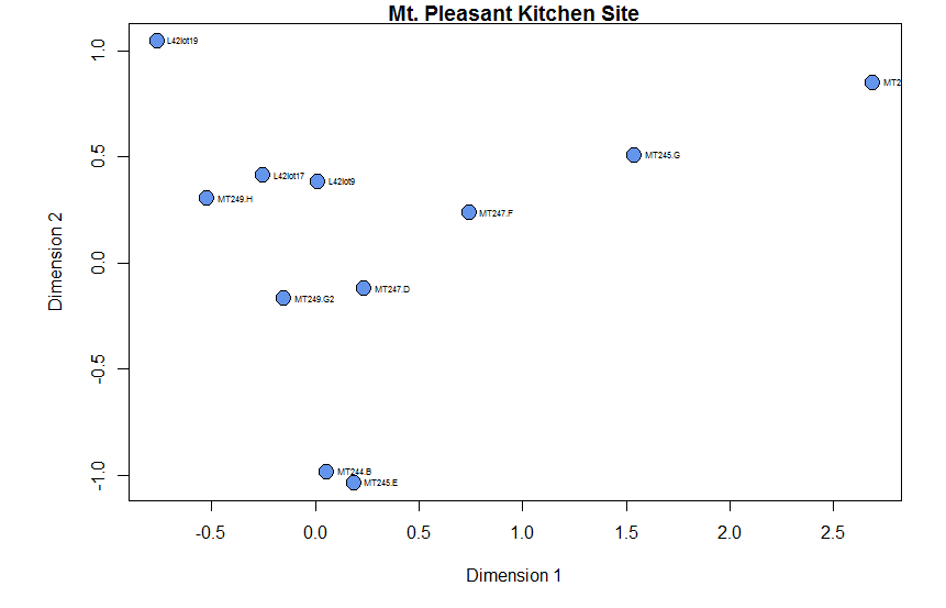
No stratigraphic groups were assigned for the contexts included in the seriation at the time of writing. Ceramic data comes from 11 contexts associated with Feature 42. To reduce the noise introduced by sampling error, only ceramic assemblages with more than five sherds were included. We excluded assemblages from unit clean-up and surface collections. The seriation chronology presented here is the result of a correspondence analysis (CA) of ware-type frequencies from contexts that meet these requirements (Figures 1 and 2).
Incorporating data from the DAACS database, we perform the correspondence analysis using the R programming language (R Core Team 2014). The CA code was written by Fraser D. Neiman. The following packages generate the data tables, CA, and plots within this code: RPostgreSQL (Conway et al 2013), plyr (Wickham 2011), reshape2 (Wickham 2007), seriation (Hahsler et al. 2014), anacor (de Leeuw and Mair 2009), and ggplot2 (Wickham 2009).
All of the R code used in this analysis was written within the domain of the R Core Team at the R Foundation for Statistical Computing, Vienna, Austria (2014). The correspondence analysis for Mt. Pleasant was conducted by Elizabeth Bollwerk.
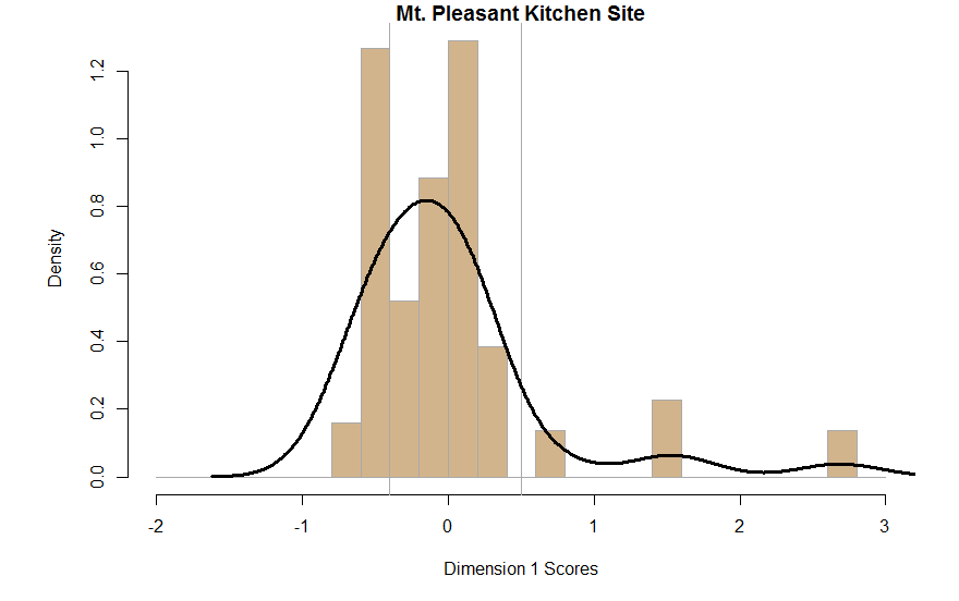
The CA results produced a strong correlation between Dimension 1 scores and MCDs (Figure 1), suggesting that Dimension 1 represents time from right (early) to left (late). Based on the dips in ceramic counts observed in a histogram of Dimension 1 scores, where the vertical axis measures ceramic assemblage size, we divided the Mt. Pleasant Kitchen Site into three occupational phases (Figure 3).
Mt. Pleasant Site Phases
DAACS Phases are groups of assemblages that have similar correspondence-analysis scores, similar MCDs, or both, and are therefore inferred to be broadly contemporary. Phases have a P-prefix that precedes the phase number (e.g. P01 equals Phase 1). Based on the correspondence analysis DAACS divided the Mt. Pleasant Kitchen Site occupation into three phases (Figures 4 and 5). Mean ceramic dates for the site-specific phases are given in the table below.
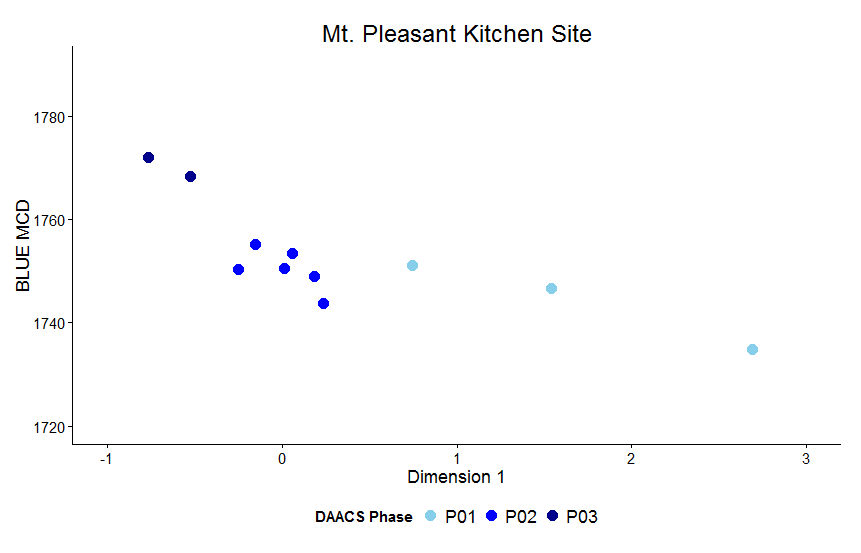
Although the correspondence-analysis did identify Phases the dimension 1 by BLUE MCD plot compared with the site’s Harris Matrix clearly indicates that the Feature 42 contexts were a jumble of secondary refuse dating from the second and third quarters of the eighteenth century. Note that a stratigraphically higher context (L42lot9) has the earliest date while context it seals (stratigraphically lower context L42lot19) has a later date.
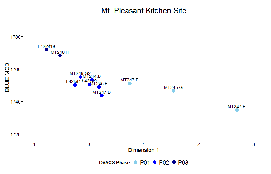
The MCDs for the three phases are given in the table below. Individual phase MCDs and BLUE MCDs, which give less influence to ceramic types withlong manufacturing spans, indicate that the Mt. Pleasant Kitchen Site was occupied throughout the second and third quarter of the eighteenth century. The table also provides three TPQ estimates. The first TPQ estimate is the usual one – the maximum beginning manufacturing date among all the ware-types in the assemblage. Two other TPQ measures included in the table below are less sensitive to excavation errors and taphonomic processes that might introduce a small amount of anomalously late material into an assemblage. They are TPQp90 and TPQp95. The TPQp95 values for each phase provide a robust estimate of the site’s TPQ based on the 95th percentile of the beginning manufacturing dates for all the artifacts comprising it. The TPQp90 value for each phase provides a more robust estimate of the site’s TPQ based on the 90th percentile of the beginning manufacturing dates for all the artifacts comprising it.
| Phase | MCD | BlueMCD | TPQ | TPQ90 | TPQ95 | Total Count |
|---|---|---|---|---|---|---|
| P01 | 1744 | 1744 | 1720 | 1720 | 1720 | 22 |
| P02 | 1744 | 1751 | 1762 | 1740 | 1740 | 136 |
| P03 | 1763 | 1768 | 1762 | 1762 | 1762 | 63 |
Harris Matrix
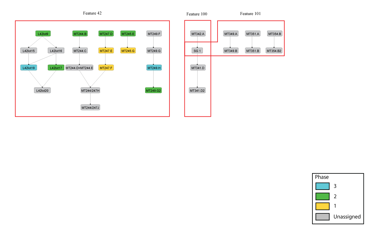
The Harris Matrix summarizes stratigraphic relationships among excavated contexts and groups of contexts that DAACS staff has identified as part of the same stratigraphic group. Stratigraphic groups and contexts are represented as boxes, while lines connecting them represent temporal relationships implied by the site’s stratification, as recorded by the site’s excavators (Harris 1979).
Stratigraphic groups, which represent multiple contexts, are identified on the diagram by their numeric designations (e.g. SG01). One stratigraphic group was assigned for this site (SG01). SG01 consists of ashy midden deposits that overlay both the entrance trench (Feature 101) and cellar (Feature 100) of the main house in a continuous deposit. The rest of the contexts are identified by their individual context numbers (e.g. MT351.A).
The upper layers of the Mt. Pleasant Kitchen Cellar (Feature 42) were excavated using the lot and locus system. The lower layers were excavated using excavation units. While natural stratigraphy was followed during both excavations, not enough information was available to enable the merging of the locus/lot contexts identified from the 1998-1999 excavations with those uncovered in 2000-2001. As a result separate areas on the Harris Matrix were generated to represent the relationships between stratigraphic groups for each excavation season.
Boxes with color fill represent contexts and stratigraphic groups with ceramic assemblages large enough to be included in the DAACS seriation of the site (see Mt. Pleasant Chronology for stratigraphic and phase information). Their seriation-based phase assignments are denoted by different colors to facilitate evaluation of the agreement between the stratigraphic and seriation chronologies. Grey boxes represent contexts that were not included in the seriation because of small ceramic samples.
See the Mount Pleasant Chronology for stratigraphic and phase information. Please note that some of the contexts present in the chronology analysis are not visualized on the Harris Matrix. The contexts that are not included do not have any stratigraphic relationships with other contexts. The lack of relationships can occur for a few reasons but two common examples are 1) the artifacts are from a surface collection, which is entered into DAACS as a context but does not have recorded relationships to other contexts that are below it; 2) in cases where topsoil and plowzone are stripped and discarded, there may be features below the plowzone that are comprised of a single context. Since the plowzone does not exist as a documented context with artifacts, it cannot seal the single-context feature. DAACS also does not record subsoil as a context, so there is nothing for that single context feature to intrude or seal.
Although the correspondence-analysis did identify Phases the dimension 1 by BLUE MCD plot compared with the site’s Harris Matrix clearly indicates that the Feature 42 contexts were a jumble of secondary refuse dating from the second and third quarters of the eighteenth century. Note that a stratigraphically higher context (L42lot9) has the earliest date while context it seals (stratigraphically lower context L42lot19) has a later date.
This Harris Matrix is based on data on stratigraphic relationships recorded among contexts in the DAACS database. It was drawn with the ArchEd application.
For a printable version, download the Harris Matrix [PDF].
Bibliography
Chambers, Douglas B.
2005 Murder at Montpelier: Igbo Africans in Virginia. University Press of Mississippi: Jackson MS.
Chambers, Douglas B.
1991 The Making of Montpelier: Col. James Madison and the Development of a Piedmont Plantation, 1741-1774. Master’s thesis, Department of History, University of Virginia, Charlottesville, VA.
De Leeuw, Jan , and Patrick Mair
2009 Simple and Canonical Correspondence Analysis Using the R Package anacor. Journal of Statistical Software, 31(5): 1-18.
Hahsler, Michael , Kurt Hornik , and Christian Buchta
2008 Getting things in order: An introduction to the R package seriation. Journal of Statistical Software, 25(3):1-34.
Harris, Edward C.
1979 Principles of Archaeological Stratigraphy. Academic Press, London, England.
Miller, Ann L.
1995 The Short Life and Strange Death of Ambrose Madison. Orange County Historical Society, Orange, VA.
Reeves, Matthew , and Kevin Fogle
2007 Excavations at the Madison’s First Home, Mount Pleasant: Summary of Archaeological Excavations 1997-2004. Manuscript, James Madison’s Montpelier, Montpelier Station, VA. Manuscript, James Madison’s Montpelier, Montpelier Station, VA. PDF available at
http://www.montpelier.org/files/excavations-madisons-first-home-mount-pleasant-1723-1800
Reeves, Matthew , and Mark Trickett
A Brief History of the Mansion Grounds. Manuscript, James Madison’s Montpelier, Montpelier Station, VA. A Brief History of the Mansion Grounds. Manuscript, James Madison’s Montpelier, Montpelier Station, VA. PDF available at http://www.montpelier.org/sites/default/files/A%20Brief%20History%20of%20the%20Montpelier%20Landscape-revised_0.pdf
Reeves, Matthew , and Kevin Fogle
2007 Appendices for the Mount Pleasant Report
Team, R Core
2014 R: A language and environment for statistical computing. R Foundation for Statistical Computing. Vienna, Austria. URL http://www.R-project.org/.
Wickham, Hadley
2011 The Split-Apply-Combine Strategy for Data Analysis. Journal of Statistical Software, 40(1):1-29.
Wickham, Hadley
2009 gplot2: elegant graphics for data analysis. New York: Springer.
Wickham, Hadley
2007 Reshaping Data with the Reshape Package. Journal of Statistical Software, 21(12), 1-20.
Images & Maps